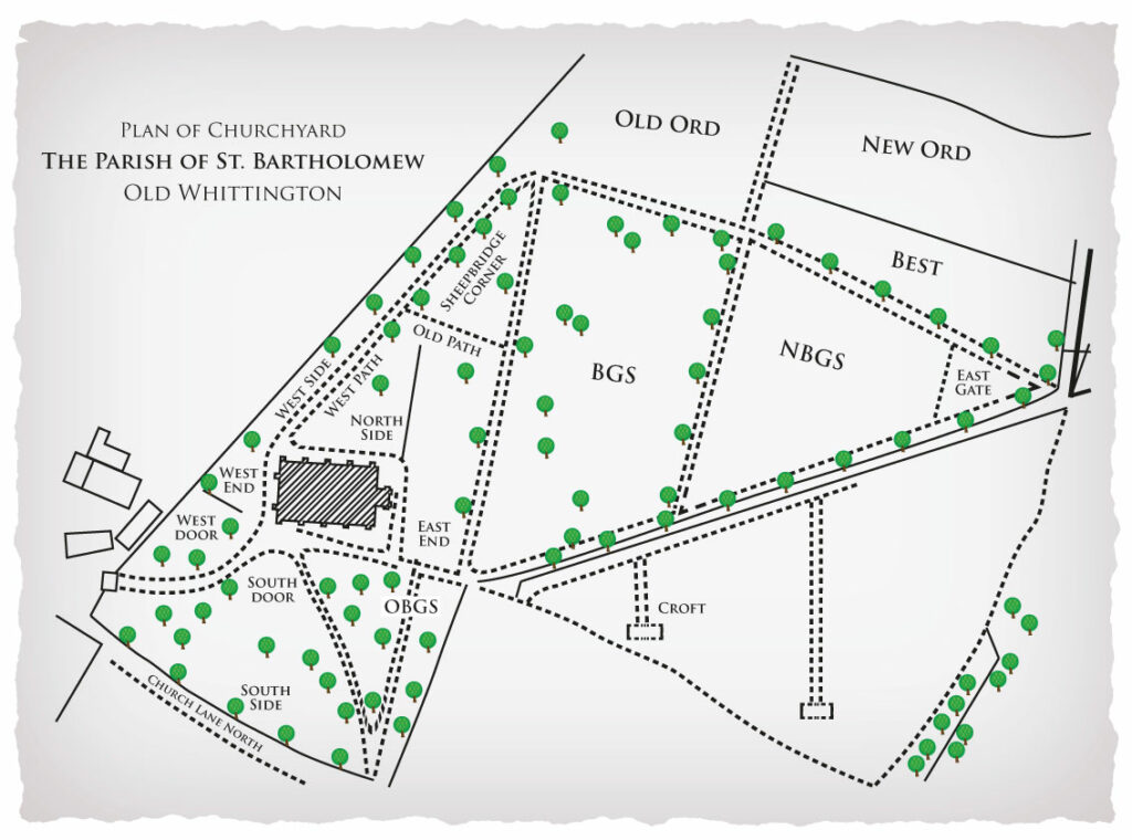
Area 1 (South Door, South Side, OBGS and West Door)
The churchyard was opened with the original church, sometime in the Twelfth Century, The church was located centrally roughly just below the text ‘South Door’. Burials continued in this area for many years with the space being reused regularly, until permanent memorials were introduced which prevented this. The earliest memorials in the churchyard are found at the east end of the original church. There are 8 memorials with dates from the Seventeenth Century – the earliest date being for a Mary Stubbinge who died 4 August 1673.
The area was left when the churchyard expanded, but at the beginning of the Twentieth Century, when space was becoming limited, further burials were carried out between the new church door and the old church foundations (South Door) and east of the path leading from the church to the small gate (OBGS or Old Burial Ground South). The area is now generally known as South Side, except for the area north of the path to the Lych Gate and west of the current church which is West Door.
Area 2 (West End, West Side, East End, Old Path, Sheepbridge Corner and Middle Path)
When the new church was built in 1863, the churchyard was expanded with the triangular plot which is area 2. Originally this was split into 2 parts with an east-west path roughly where the line is on the plan. There is some evidence of an original numbering system – rows 20 to 34, but this has been obscured by later developments. This makes for a very complicated area which has been reused successively with different names being used at different times.
Cremated remains were interred in the area to the west of the church (spilling into area 1) and this was called West End, though it is contiguous with West Door and the cremation plots are interspersed with these burials.
The areas either side of the path going north east from the west door of the church were used mainly for child burials. Those on the west side of the path, between it and the wall are known as West Side, whilst those on the east side are known as West Path. There are some adult burials at the church end of West Side, and these may, originally, have been part of West Door.
The area to the East of the church up to the original east-west path is East End, whilst the area west of this, and possibly bounded by the path is North Side, – the later children’s burials of West Path work around some of the earlier graves of this. Shortly before the churchyard was closed the east-west path was used for burials – Old Path.
The triangular section to the north of Old Path was, at one time, called Sheepbridge Corner, though to the west there are child burials which seem to be part of West Path, and the area to the east was reused and called Middle Path.
Area 3 (BGS)
This was opened in around 1890 and is known as BGS – Burial Ground South. The area has not been reused in any way, though the relative lack of memorials can make it difficult to locate a specific plot.
Area 4 (Old Ord)
This was opened in 1913 and was originally known as Ord or Ordinary though it is now known as Old Ord. It has not been reused.
Area 5 (NBGS and East Gate)
This was opened in 1924. The western end is NBGS – New Burial Ground South, whilst the eastern end at the point of the triangle is East Gate. It has not been reused.
Area 6 (Best and New Ord)
This was opened in 1931. The southern side, adjoining the path is Best, whilst the northern side adjoining the hedge is New Ord – New Ordinary. It has not been reused.
Area 7 (Croft)
This was opened in 1981 and is known as the Croft. It is the only part of the churchyard which is currently open for new burials. All other areas have been closed and may only be used for interment into existing family graves if room permits.
Areas 1 – 6 are considered closed and as such are now maintained by Chesterfield Borough Council. That being the case as in other Council owned grounds dogs must be kept on leads and any mess cleared up after them.